Hesatu Plateau Viewpoint, Latehar
Hesatu Plateau Latehar — Elevated Viewpoint & Grassland, Jharkhand
The Forgotten Jharkhand Plateau — Elevated Grassland and Forest at Latehar's Northern Edge
About Hesatu Plateau Viewpoint, Latehar
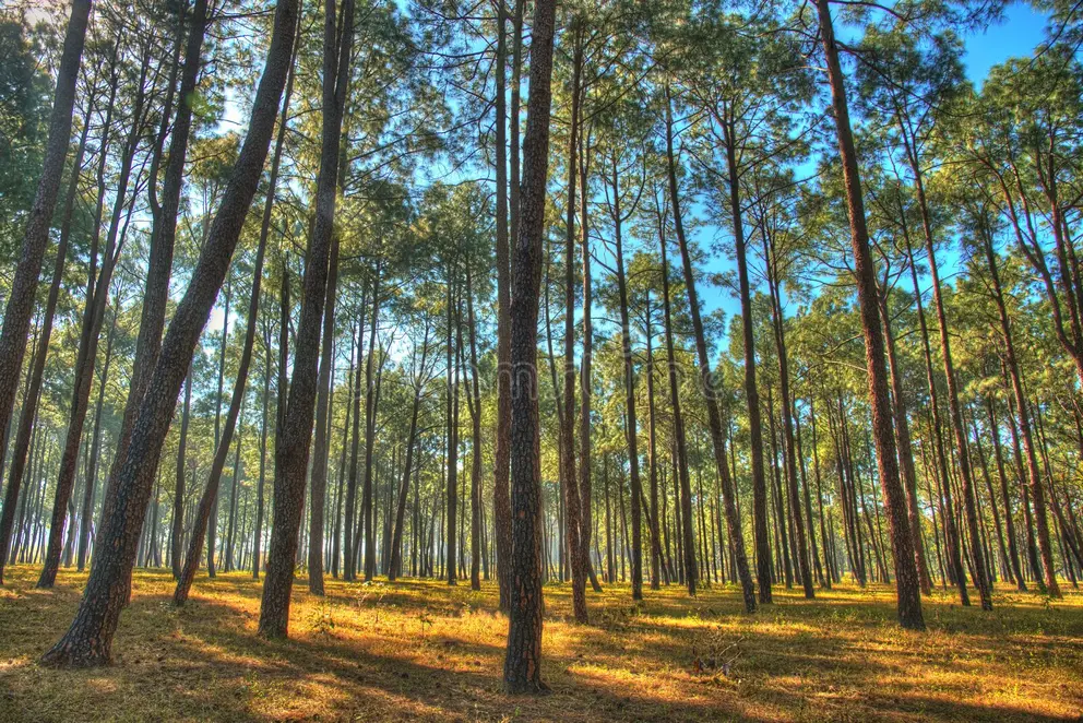
Hesatu is a plateau grassland area on the Latehar–Ranchi boundary at an elevation of approximately 900 metres, where the Chotanagpur plateau's highest sections support a mosaic of grassland and patchy forest with extensive views over the surrounding lower plateau. The area provides some of the most open plateau landscape in Jharkhand, distinct from the closed-canopy sal forest that covers most of the region.
The Hesatu plateau sits at the highest elevation band of the Chotanagpur upland — the same altitude range as Netarhat (1,100 metres) to the south and the Hazaribagh plateau to the northeast. At this elevation, the vegetation character shifts from the dense sal forest of the lower plateau to a more open mosaic: short grassland on exposed ridge crests, patchy mixed forest in sheltered depressions, and rocky granite outcrops that punctuate the grassland. The grassland character at Hesatu creates a landscape experience unusual in Jharkhand: instead of looking up into a forest canopy, you look out across a wide open plateau with extensive sky. The plateau views extend north toward the Ranchi urban fringe and south toward the deeper forest of Latehar district — a position that reveals the broad spatial structure of the Chotanagpur landscape. The open grassland supports a different bird community from the sal forest — the open-country raptors (migratory harriers in winter, resident buzzards and eagles year-round), grassland larks and pipits, and the large Indian roller hunting from fence posts and lone trees across the grass. Indian fox and civets are regular in the grassland edge at dawn and dusk. Hesatu is accessible on a good road from the Ranchi–Latehar highway and makes a feasible half-day from Ranchi for visitors who want to experience the elevated plateau grassland character of Jharkhand's highest terrain.
Plan Your Visit
Get personalised travel recommendations for Hesatu Plateau Viewpoint, Latehar
Enquire NowQuick Info
October to March
Latehar
adventure
Location
Latehar District, Jharkhand · 93 km from Ranchi
Hesatu Plateau Viewpoint, Latehar
Latehar District, Jharkhand
Frequently Asked Questions About Hesatu Plateau Viewpoint, Latehar
Common questions about visiting Hesatu Plateau Viewpoint, Latehar, Jharkhand
Hesatu is a plateau grassland area on the Latehar–Ranchi boundary at approximately 900 metres elevation, offering an open grassland landscape with extensive plateau views unusual in forested Jharkhand. It provides accessible elevated plateau experience 93 km from Ranchi.
Hesatu is approximately 80–93 km from Ranchi on the Ranchi–Latehar highway — about 2 hours by vehicle. State buses toward Latehar pass nearby.
October to March for the most pleasant weather. Winter (November–February) is best for migratory harrier sightings on the open grassland. The monsoon turns the plateau green but the access road can be difficult.
Looking for a Stay?
Find the best hotels and resorts near your destination
Need a Ride?
Book a comfortable AC car with driver for your Jharkhand trip
Explore More Destinations in Jharkhand
Continue your Jharkhand adventure with these nearby and similar destinations